Report to: Development Services Committee Report Date: June 22, 2010
SUBJECT: RECOMMENDATION
REPORT
2162246 Ontario Ltd
(Best Homes Canada Inc)
Applications for Draft
Plan of Subdivision and Zoning By-law Amendment to permit townhouse and high density
mixed-use residential development at 9582 Highway 48
Wismer Commons Community
Files Numbers: SU
09-124456 and ZA 08-120818 (19TM-09006)
PREPARED BY: East
District Team
RECOMMENDATION:
1)
That the recommendation report dated June 22, 2010 entitled
“Recommendation Report. 2162246 Ontario
Ltd (Best Homes Canada Inc). Applications
for Draft Plan of Subdivision and Zoning By-law Amendment to permit townhouse
and high density mixed-use residential development at 9582 Highway 48, Wismer Commons
Community, File Numbers: SU 09-124456 and ZA 08-120818 (19TM-09006)”, be
received.
2)
That the record of the Public Meeting held on October
20, 2009, regarding the applications for the Draft Plan of Subdivision and
Zoning By-law amendment be received;
3)
That the draft plan of subdivision (19TM-09006) submitted
by 2162246 Ontario Ltd (Best Homes Canada Inc) be approved subject to the conditions
of draft approval attached as Appendix ‘A’;
4)
That the application submitted by 2162246 Ontario Ltd
(Best Homes Canada Inc) to amend Zoning By-laws 304-87 and 177-96 as
amended, be approved and the draft by-law, attached as Appendix ‘B’ be finalized
and enacted without further notice;
5)
That the Mayor and Clerk be authorized to enter into a
No Presales Agreement for Blocks 1 to 4, to be registered on title and
committing the Owner not to enter into any agreements of purchase and sale with
anyone, including other developers or builders until the Director of
Engineering is satisfied that a full moves access from the plan of subdivision
to either Highway 48 or to Bur Oak Avenue has been provided for;
6)
That 21 units (59.2 population) of conditional 2011
servicing allocation be granted to this development, as assigned in accordance
with the February 12, 2008 and May 19, 2009 reports on servicing allocation;
7)
That the Mayor and Clerk be authorized to enter into a
No Presales Agreement for Block 5, to be registered on title and committing the
Owner not to enter into any agreements of purchase and sale with anyone,
including other developers or builders until:
a) York Region has advised in
writing that the expected completion of the Southeast Collector Sewer will be
within twelve (12) months; and
b) The Council of the Town of
Markham has allocated adequate available water supply and sewage servicing
capacity to the lands.
8)
That the Town reserves the right to revoke or
reallocate servicing allocation should the development not proceed in a timely
manner;
9)
That the Owner provide the Town with the required
payment of 30% processing fees in accordance with the Town’s applicable Fee
By-law;
10)
That draft plan approval shall lapse after a period of
three (3) years from the date of approval in the event that the conditions of
approval have not been satisfied within that period;
11)
And that Staff be authorized and directed to do all
things necessary to give effect to this resolution.
EXECUTIVE SUMMARY:
The subject lands consist of a 1.59
hectare (3.8 acre) property located on the west side of Highway 48, south of
Bur Oak Avenue, and municipally known as 9582 Highway 48. The
original conceptual site plan submitted with the 2008 zoning amendment
application consisted of a 10 storey, 99-unit apartment building fronting
Highway 48, with 72 stacked condominium townhouse units on an internal private
road.
The application
has been revised to be consistent with the new staff concept for the Highway 48
Corridor, which provides for higher density fronting Highway 48 and lower
densities in the interior of site. The
proposed draft plan of subdivision, submitted in late 2009, consists of a high
density mixed-use residential block fronting Highway 48, 21 lane-based
townhouse lots on a public road in the interior of the site and a 0.49 ha park
block on the western portion of the subdivision fronting on the new public road
and Hammersley Boulevard.
The proposed
development is intended to be accessed in the short term by a single right-in/right-out
access from Highway 48 at the southern limit of the property, a portion of
which is provided on abutting lands to the south owned by Great Eldin. The plan of subdivision also includes a
north-south public road identified as Street ‘B’ which provides frontage for
the townhouse lots and public frontage for the park block from the interior of
the site. This public road is intended to ultimately
extend northward to Bur Oak Avenue, and southward to Highway 48 through
abutting properties.
The subject lands are designated
‘Major Commercial Area’ in the Wismer Commons Secondary Plan which provides for
medium and high density mixed-use development. Staff are
satisfied that the 21 proposed townhouse units and the 218 apartment units
anticipated in Block 5 can be built within the 1.75 floor space index maximum
provided for in the Wismer Commons Secondary Plan.
The issues
identified at the Public Meeting held in November, 2009 have been addressed.
The high
density mixed-use residential block will be subject to site plan control. The delineation of the preserved area of the
‘Matrundola Woodlot’ to the south will determine the future public road
alignment and park size. Final approval of the plan of
subdivision will be subject to the applicant obtaining a full moves access from
either Bur Oak Avenue or Highway 48 through abutting lands to the north or
south.
A portion (59.2 population) of the conditional 2011 allocation available to
the applicant will be used to serve the 21 townhouse units. A holding provision will be included in the
zoning by-law, consistent with Town and Region of York requirements, applying
to the apartment units for which allocation is not available.
The applicant will be required to
have regard for the Region of York’s “Sustainable Housing Incentive Program”
for low density residential development.
Future proposed development within the high density mixed-use
development block (Block 5) will be required to achieve a LEED Silver
certification.
The proposed zoning by-law amendment,
attached as Appendix ‘B’ permits the townhouse development within Blocks 1 to
4, and permits a maximum of 218 apartment units within the high density
mixed-use block (Block 5) fronting Highway 48.
The zoning also provides for a maximum height of 18 storeys for the
future apartment building in Block 5.
The zoning is subject to Holding provisions for access and servicing
allocation.
Staff recommend draft plan approval subject to the
conditions outlined above and in the conditions of draft approval attached as
Appendix ‘A’. Staff
further recommend that the draft zoning by-law attached as Appendix ‘B’
be finalized and enacted.
The purpose of this report is to recommend approval of a
draft plan of subdivision and implementing zoning by-law amendment for medium
and high density residential development and to recommend that servicing
allocation be granted for a portion of the subdivision.
Property and
Area Context
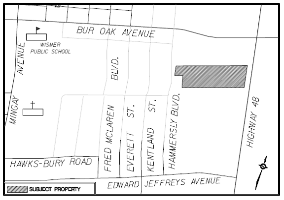
The subject lands consist of a 1.59 hectare (3.8 acre)
property located on the west side of Highway 48, south of Bur Oak Avenue, and municipally
known as 9582 Highway 48. The subject
lands are currently vacant with a few trees along the north and south property
line (Figure 1).
To the west of the property across Hammersly Boulevard are
lands subject to proposed residential plans of subdivision. To the north are
lands intended for mixed use residential/commercial development. The “Matrundola Woodlot” and vacant lands
intended for mixed use development are located on the lands to the south. To the east, across Highway 48, are industrial/commercial
uses and the Mount Joy Go station (Figures 2 and 3).
The site was
subject to a previous site plan application
The original site plan concept submitted with the zoning
amendment application in 2008 consisted of a 10 storey, 99-unit apartment building
fronting Highway 48, with 72 stacked townhouse units on an internal private
road. A small number of single detached
and semi-detached units were also proposed fronting on Hammersly
Boulevard. The concept also included a
small area of open space/parkland between the private road and Hammersly
Boulevard.
Proposal has
been revised in accordance with the Town’s emerging vision for the Highway 48
Corridor
Since the fall of 2008, staff have
been working towards a Town-initiated Official Plan Amendment (OPA) to
implement the 2005 Highway 48 Urban Design
Study. This study provided development
guidelines for the lands fronting Highway 48 between 16th Avenue and Major Mackenzie Drive. The most recent staff concept plan for the
lands on the west side of Highway 48 between Bur Oak Avenue and Edward Jeffreys Avenue was presented to
Committee in October 2008. The concept included
the introduction of a new north-south public street, community parkland and high
density mixed-use residential development in the form of podiums with point
towers in strategic locations fronting Highway 48. The revised concept was in response to staff
concerns with various proposals by landowners, depicting multiple building
masses along the Highway 48 corridor, creating a ‘10 storey wall’ of buildings
with limited character or architectural variety. Staff proposed that the introduction of point
towers would provide a variety of architectural building massing while
maintaining the same densities. By providing
for towers in strategic locations, the corridor would create visual interest in
the streetscape and provide openings into the skyline.
The applicant has been working with staff since 2008 to
revise their application to be consistent with this new concept. The original design of a 10 storey building
fronting onto Highway 48 and stacked townhouses on a private road internal to
the site, has been revised to transfer density and
height to the Highway 48 frontage and decrease the density in the interior of
the site. The revised proposal also
provides a portion of the north-south public road as well as public parkland contemplated
in the revised design concept for the area.
The applicant is proposing townhouse and high density
mixed-use development
The draft plan of subdivision consists of a high density mixed-use
residential block fronting Highway 48, 21 lane-based townhouse lots in the
interior of the site and a 0.49 ha park block in the western portion of the
subdivision fronting on Hammersley Boulevard, as shown in Figure 4. The draft plan originally included 5
semi-detached lots fronting Hammersly Boulevard, but the applicant has removed these
lots from the draft plan of subdivision, and instead intends to create the lots
through severance.
The proposed development is intended to be accessed in the
short term by a single right-in/right-out access from Highway 48 at the
southern limit of the property, a portion of which is provided on abutting lands
to the south owned by Great Eldin. The plan
of subdivision also includes a north-south looped public road system identified
as Street ‘B’ which provides frontage for the townhouse lots and public
frontage for the park block from the interior of the site. This
public road is intended to ultimately extend northward to Bur Oak Avenue, and
southward to Highway 48 through the abutting properties through future
development applications.
Official Plan
and Zoning
The subject
lands are designated ‘Major Commercial Area’ in the Wismer Commons Secondary
Plan which provides for medium and high density mixed-use development.
The Secondary
Plan provides that the permitted density of development within the ‘Major
Commercial Area’ designation be based on the urban residential policies of the
Secondary Plan and that buildings shall generally not exceed a floor space
index of 1.75. Staff are satisfied that the 21 proposed
townhouse units and the 218 apartment units anticipated in Block 5 can be built
within the 1.75 floor space index maximum.
The lands are
currently zoned Rural Residential (RR2) under By-law 304-87, as amended. The proposed zoning by-law amendment to
implement the draft plan of subdivision is discussed in further detail below.
Recommendations regarding proposed Section 37 Official
Plan policies and implementation guidelines were considered by Committee in May
2010. Section 37 of the Planning Act is a planning tool that allows
municipalities to grant an increase in height and/or density in return for
additional services, facilities and other community benefits. With respect to
this application, since the density being approved does not exceed the maximum
density permitted by the Wismer Commons Secondary Plan, and height thresholds
(minimum or maximum) are not contemplated in the Secondary Plan, Section 37
does not apply.
The proposal
is generally consistent with the Town’s emerging vision for Highway 48
The Highway 48 Urban Design Study, endorsed by Council in
October 2005, provides urban design and development guidelines to be used in
the evaluation of development applications within the Highway 48 corridor
between 16th Avenue and Major Mackenzie Drive. The purpose of the urban design guidelines is
to encourage a high quality, mixed use and pedestrian friendly district that
better supports street-oriented retail and residential uses and provides a
focus for the community.
The subject lands are identified within the ‘Transition
and Intensification District’. This
district envisions that lands between Edward Jeffreys Avenue and Bur Oak Avenue
be utilized as a transitional zone between the heritage district to the south
and development to the north, consisting of development in the form of
multi-storey buildings with grade related retail, service and office uses. Guidelines for this district call for:
As mentioned
previously, staff have been working towards a Town-initiated
Official Plan Amendment to implement the urban design vision for the
corridor. Since work began on the
Official Plan Amendment in late 2006, staff have been
reconsidering the appropriate built form for high density residential
development in the corridor, from buildings between 8 to 10 storeys in height,
to a combination of podiums and point towers, as reflected in the revised
concept presented to Development Services Committee in 2008. For the subject
lands, the revised proposal is in keeping with the revised staff concept, which
includes buildings with podiums with point towers at strategic locations along
the Highway 48 frontage and a medium density built form at further distances
from Highway 48, adjacent to existing low density communities.
Issues
identified at the Public Meeting have been addressed
A Public Meeting for the draft plan of subdivision and
zoning amendment applications was held on October 20, 2009. Many of the comments from Committee and
residents pertained to the high density portion of the draft plan of
subdivision, which fronts Highway 48.
Comments also included concerns related to the provision of adequate
access to the proposed public park east of the subject lands, pedestrian
linkages through the park from Hammersly Boulevard to Highway 48, and the
provision of a buffer area from the woodlot in excess of 10 metres.
The high density mixed-use residential block will be
subject to site plan control
The applicant has requested that Block 5 fronting Highway
48 be zoned as part of this application, prior to site plan approval. Staff have agreed to
zone the block in accordance with the density provisions of the Wismer Commons
Secondary Plan which provides for a maximum floor space index of 1.75. As discussed previously, staff
are satisfied that the 21 townhouse units and 218 apartment units can be
developed with the 1.75 FSI maximum. A
maximum height of 18 storeys is considered appropriate in this location. Site
plan approval by Council will be required for any development within this
block. The implementing by-law contains
an (H) Holding provision requiring the applicant to execute a site plan
agreement with the Town.
Delineation of the preserved area of the ‘Matrundola Woodlot’
to the south will determine the future public road alignment and park size
The alignment of Street ‘B’ is
dependent on the limit of the preservable area of the Matrundola woodlot to the
south. The proposed alignment is
generally in accordance with previous assessments which have concluded that the
core area is along the western limit of the woodlot. The limits of the portion of the woodlot to
be preserved will be determined through an updated arborist’s report, and will
include the provision of 10m environmental buffer. Street ‘B’ will provide direct public access
to the preserved portion of the woodlot.
Town staff have recently been on site with the applicant’s
consultants to begin the process to determine the limit of preservation. As a condition of approval, the applicant will
be required to participate in the development of a Woodlot Assessment and
Management Plan for the preserved area of the woodlot.
The size of the park (shown as
approximately 0.5 ha in the draft plan) will also be confirmed once the area of
the woodlot to be preserved, and the alignment of Street ‘B’, is
confirmed. The park is located immediately north of the preserved
area of the woodlot and will be accessible directly from Street ‘B’ and from
Hammersly Boulevard. The park is intended to become
part of an integrated parks and open space system which
will serve the population resulting from high density residential
development in this portion of the Highway 48 Corridor.
The remainder of the applicant’s required parkland dedication requirement
will be taken as cash-in-lieu.
Public access to the park
As mentioned above, the park will have public access from
both Hammersley Boulevard (approximately 31 metres) and Street ‘B’. The provision of a continuous pedestrian
access from Hammersly Boulevard through the future park to Highway 48 will be
addressed during the detailed design of the park and through site plan approval
for the high density block fronting Highway 48.
Final approval will be subject to conditions
regarding access
A single right-in/right-out access from Highway 48 is
being proposed to provide interim access to the site. A portion of the access is proposed on the
lands to the south (Great Eldin). Staff are not satisfied that the proposed single restricted access
is sufficient to serve the needs of this development, and are requiring that
full moves access from either Bur Oak Avenue or Highway 48 through abutting
properties be confirmed prior to sales of the townhouse lots and prior to
registration of the plan of subdivision.
Servicing Allocation
The applicant has indicated they have
conditional 2011 servicing allocation for 113.5 population as assigned by
Council in May 19, 2009. The applicant
intends to use a portion of this allocation (59.2 population)
to serve the 21 townhouse units. A
Holding provision will be included in the zoning by-law consistent with Town
and Region of York requirements for the apartment units for which allocation is
not available.
Sustainability Initiatives
The applicant
will be required to have regard for the Region of York’s “Sustainable Housing
Incentive Program” for low density residential development. The future proposed development within the
high density mixed-use development block (Block 5) will be required to achieve
a LEED Silver certification. These
design elements, including bird friendly design, dark skies, water efficient
landscaping and storage and security for alternative modes of transportation
will be addressed through the site plan approval process. A final site plan for the high density block will
be brought forward to Development Services Committee for final approval at a
later date.
Proposed
Zoning By-law Amendment
The proposed zoning by-law amendment, attached as Appendix
‘B’ permits the townhouse development within Blocks 1 to 4, and permits a maximum
of 218 apartment units within the high density mixed-use block (Block 5)
fronting Highway 48. The zoning also provides
for a maximum height of 18 storeys for the future apartment building in Block
5. The zoning is subject to Holding provisions for
access and servicing allocation.
Not applicable.
Not applicable.
The proposed application aligns with the Town’s strategic
priorities of Growth Management and Municipal Services by implementing the
proposed development in coordination with available servicing allocation, and
providing for an appropriate level of development within an identified
intensification area. The proposal also
aligns with the strategic focus of Environment and Parks and Recreation.
The applications have been reviewed by various Town
departments and external agencies.
Requirements of the Town and external agencies are reflected in the
implementing zoning by-law amendments and conditions of draft approval.
CONCLUSIONS:
Staff recommend draft plan approval subject to the
conditions outlined above and in the conditions of draft approval attached as
Appendix ‘A’. Staff further
recommend that the draft zoning by-law attached as Appendix ‘B’ be
finalized and enacted.
RECOMMENDED BY:
____________________________ ____________________________
Biju Karumanchery, M.C.I.P,
R.P.P Jim Baird, M.C.I.P, R.P.P
Senior Development Manager Commissioner, Development Services
Figure 1 –
Location Map
Figure 2 –
Area Context and Zoning
Figure 3 –
Air Photo
Figure 4 –
Draft Plan of Subdivision
Figure 5 –
Conceptual Townhouse Elevations
Figure 6 –
Conceptual High Density Block Elevation
Appendix ‘A’
– Conditions of Draft Plan Approval
Appendix ‘B’
– Draft zoning by-law amendments
File path: Amanda\File 09
124456\Documents\Recommendation Report
APPLICANT/AGENT: Shakir Rehmatullah
2162246 Ontario Ltd
(Best Homes Canada Inc)
3601 Hwy 7 E, Unit 309
Markham, ON L3R 0M3
Tel: 905-479-9292
Fax: 905-479-0165
shakir@flatogroup.com
Figure 1 – Location Map